
Rooklyn at a glance
Full Gangstar Mirage City map
The current map names 15 districts. Open the image for a larger view, then use the region filter to narrow the district directory.
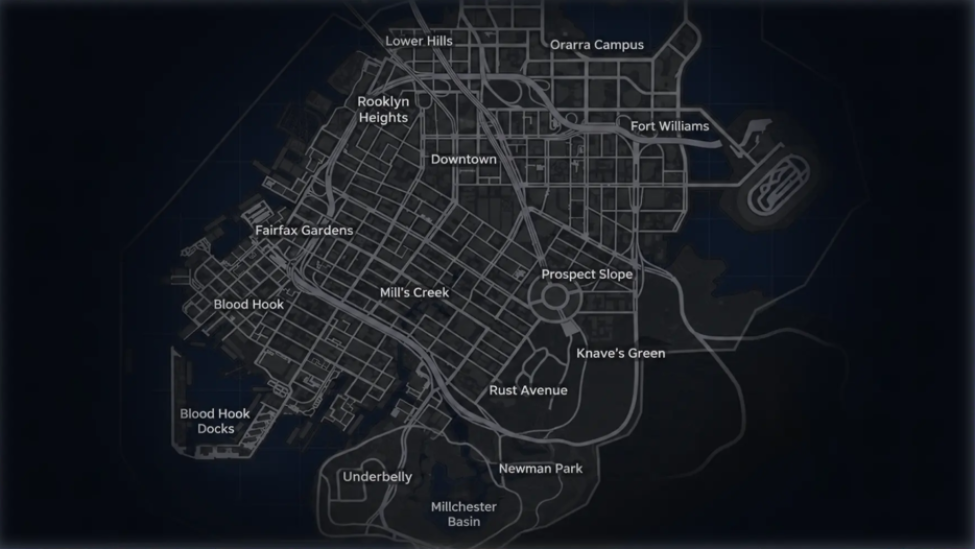 Open full-size map
5 districts
Northern Core
Dense northern streets, campus blocks, Downtown and the eastern Fort Williams route.- Lower Hills
- Rooklyn Heights
- Downtown
- Orarra Campus
- Fort Williams
5 districts
Central Streets & Waterfront
West-side city blocks, Mill’s Creek, Prospect Slope and the Blood Hook waterfront.- Fairfax Gardens
- Blood Hook
- Blood Hook Docks
- Mill’s Creek
- Prospect Slope
5 districts
Southern Edge
The lower road network around Knave’s Green, Rust Avenue, Underbelly, Newman Park and the basin.- Knave’s Green
- Rust Avenue
- Underbelly
- Newman Park
- Millchester Basin
District directory
Browse all 15 Rooklyn districts
Lower Hills
Map position: Northern edge, above Rooklyn Heights and west of Orarra Campus.
A compact northern grid connected to the upper highway network.
Rooklyn Heights
Map position: Upper-west Rooklyn, west of Downtown and below Lower Hills.
Hillside streets feed into the western side of the northern city.
Downtown
Map position: Central-north, between Rooklyn Heights and Fort Williams.
A dense central street grid with direct routes toward the other northern districts.
Orarra Campus
Map position: Upper-east, east of Lower Hills and north of Fort Williams.
Campus blocks sit beside the northern highway and eastern road network.
Fort Williams
Map position: Eastern side of the northern city, east of Downtown.
An eastern route beside the waterfront and the isolated oval road complex.
Fairfax Gardens
Map position: Mid-west, north of Blood Hook and west of Mill’s Creek.
Western streets connect the northern districts to Blood Hook.
Blood Hook
Map position: Western waterfront, below Fairfax Gardens.
A coastal street grid leading toward Blood Hook Docks.
Blood Hook Docks
Map position: Southwestern waterfront, directly below Blood Hook.
The dock road is separated from the inland grid by the shoreline.
Mill’s Creek
Map position: Central-west, east of Blood Hook and southwest of Downtown.
A broad central connector between the western waterfront and Prospect Slope.
Prospect Slope
Map position: Central-east around the large circular junction.
The roundabout links the central grid with Knave’s Green and eastern roads.
Knave’s Green
Map position: Southeast of Prospect Slope and east of Rust Avenue.
Open southern roads connect the central junction to the lower districts.
Rust Avenue
Map position: South-central, below Mill’s Creek and west of Knave’s Green.
A curved road network forms the transition into the Southern Edge.
Underbelly
Map position: Southwestern corner, west of Millchester Basin.
A compact lower road loop sits apart from the central street grid.
Newman Park
Map position: Lower-east, below Rust Avenue and Knave’s Green.
Southern roads meet near the park before continuing toward the basin.
Millchester Basin
Map position: Southern edge, between Underbelly and Newman Park.
The basin occupies the lowest central part of the Rooklyn map.
What to look for
Map locations by activity
Markers can appear as the related activity or service unlocks. Use the active in-game label when a marker is not yet visible on the account.
Missions
Track story, Contact, Company, job and Crew objectives from the current mission list.
Open related guideGarages and vehicles
Use dealer, garage and race markers for buying, storing, upgrading or entering vehicle activities.
Open related guideApartments and safe interiors
Look for property or interior markers tied to the current account progression.
Businesses
Company and business locations connect to criminal-empire progression and income activities.
Open related guideHeists and events
Crew heists, races and limited activities can depend on prerequisites, team state or event schedule.
Open related guideWatch in page
Gangstar Mirage City map videos
Watch the full-map and location walkthroughs on this page. If playback is unavailable, use the YouTube fallback shown in the player.
On this page
- Full map
- District directory
- Location types
- How to use the map during a mission
- Mini-map signals and markers
- Map size and boundaries
- Where are the police station and military base?
- Vehicle locations shown in community videos
- Useful routes from the district map
- Continue from the map
- Gangstar Mirage City map FAQ
How to use the map during a mission
- Select the intended story, Contact, Company, job, or Crew objective before travelling.
- Confirm that the objective marker appears on the mini-map or HUD.
- Read the district name on the full map, then choose a main road that reduces unnecessary turns.
- Check Wanted pressure before entering a mission, race, shop, or property.
- If a service marker is missing, continue the related progression path and check the map again after it unlocks.
Mini-map signals and markers
| Signal | What it tells you | Next action |
|---|---|---|
| Tracked objective | The selected task has a navigation target | Follow the route while checking the destination name |
| Police or Wanted display | Police pressure is nearby or active | Break line of sight before starting another activity |
| Shop or service marker | An unlocked service is nearby | Open the marker and confirm its current inventory or function |
| Apartment or interior | A property or usable interior is available | Check ownership and entry requirements |
| Race, heist, or event marker | An activity is currently offered | Check schedule, team, vehicle, and progression requirements |
Map size and boundaries
The current map image identifies the street network and 15 district names, but it does not provide an official square-kilometer measurement. Use district labels and visible road connections for route planning instead of an estimated map-size figure.
Where are the police station and military base?
No reliable police-station or military-base marker is available in the current map data. A recent TapTap review asks for both locations and for police officers to patrol outside an active Wanted Level, which should be treated as a feature request rather than proof of a hidden location. If a video claims to show either site, compare its district label and map marker with the current build before travelling there.
- Learn how police Wanted Level works — Use the pursuit and escape guide for police encounters that are currently documented.
- Check version and feature changes — Look for an official map or world-system addition.
Vehicle locations shown in community videos
Community videos show routes for Backbone, Theseus, Kagemusha GZ, and other rare vehicles. Use the video to identify the district and nearby landmark, then confirm the marker and vehicle name in the current build before saving a location as permanent.
- Open the Backbone report — Check the vehicle role and video evidence.
- Open the Theseus report — Verify autopilot, weapons, and current location.
| Vehicle | Video evidence | Map action |
|---|---|---|
| Backbone | Hunting and mission-driving walkthroughs | Open the current marker and record the district shown on your account |
| Theseus | Location and tactical-vehicle walkthroughs | Check the marker, ability prompt, and acquisition state |
| Kagemusha GZ | Mill’s Creek Taxi-area location walkthrough | Use the Taxi marker as a starting point and verify the current spawn |
| Other rare cars | Recent supercar-location videos | Treat each route as Reported until the same district and landmark repeat |
Useful routes from the district map
| Route | District sequence | Use |
|---|---|---|
| Northern cross-city | Rooklyn Heights → Downtown → Fort Williams | Move across the dense northern grid |
| West waterfront | Fairfax Gardens → Blood Hook → Blood Hook Docks | Reach the southwestern docks from the central city |
| Central to south | Prospect Slope → Knave’s Green → Newman Park | Follow the eastern route into Southern Edge |
| Southwest loop | Mill’s Creek → Rust Avenue → Underbelly → Millchester Basin | Move from the central-west grid into the lower districts |
Continue from the map
- Open the missions hub — Choose story, Contact, Company, job, or Crew objectives.
- Open the vehicles guide — Select a vehicle for travel, races, and getaways.
- Open the Wanted Level guide — Manage police pressure while crossing Rooklyn.
- Open the beginner guide — Follow the first-hour unlock order.
Gangstar Mirage City map FAQ
| Question | Answer |
|---|---|
| How many districts are on the Gangstar Mirage City map? | The current Rooklyn map labels 15 districts across three regional groups. |
| What are the three Rooklyn regions? | Northern Core, Central Streets & Waterfront, and Southern Edge. |
| Where is Downtown on the map? | Downtown is in the central-northern part of Rooklyn, east of Rooklyn Heights and west of Fort Williams. |
| Where are Blood Hook Docks? | Blood Hook Docks are on the southwestern waterfront, directly below Blood Hook. |
| Does the map show every shop and collectible? | The full district map shows streets and district names. Individual service, activity, and collectible markers can depend on progression, version, or the current event state. |